KAIST
BREAKTHROUGHS
Research Webzine of the KAIST College of Engineering since 2014
Fall 2025 Vol. 25Recent advances in satellite attitude guidance technology for earth observation missions
To carry out imaging missions for Earth observation satellites, precise attitude guidance commands are essential. An effective algorithm has been developed to enhance performance from the perspectives of stability and efficiency.
Satellites offer a diverse range of benefits that enhance daily life. They provide global access to essential services such as the internet, telecommunications, and television broadcasting, while also supplying location data for systems such as airplanes, drones, and autonomous vehicles. One of the most significant applications of satellite technology is providing image data, which is vital for agriculture and forest management, ocean and environmental monitoring, and the delivery of crucial information for national defense and security.
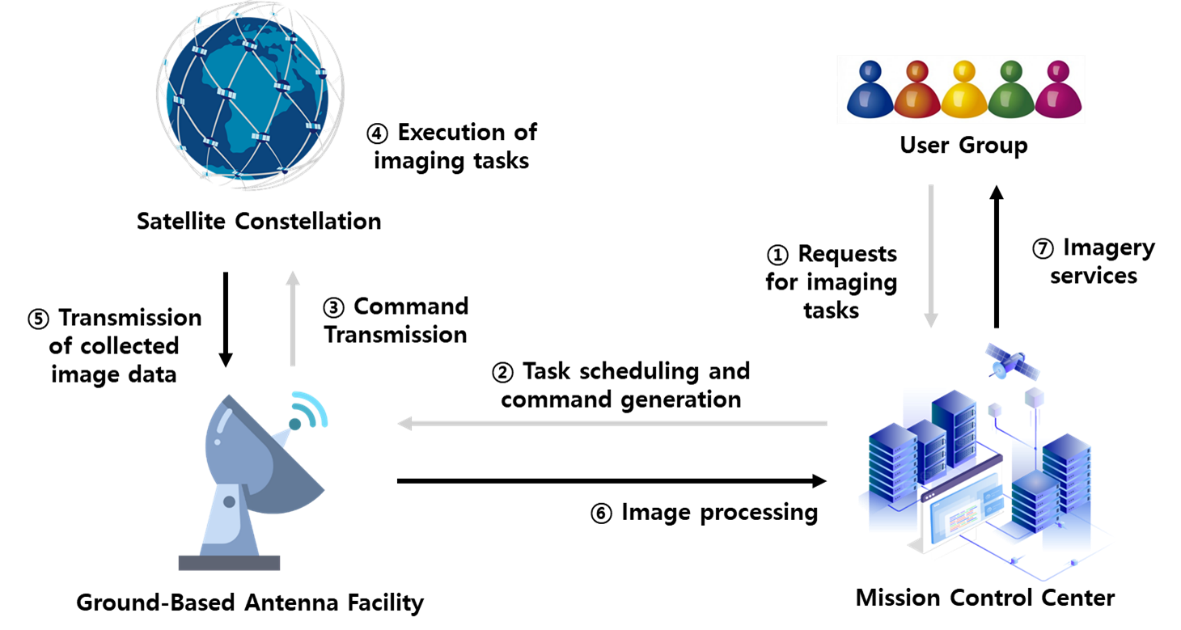
The process of acquiring image data from satellites involves several key steps, as illustrated in Figure 1. First, observation points are identified. Next, a sequence is planned to capture images at multiple observation points. Command data is then generated to guide the satellite in capturing the designated targets, and this data is transmitted to the satellite via ground antennas. Once the commands are received, the satellite adjusts its orientation to align with the target, captures the required imagery, and transmits the data back to the ground station, where it is processed and delivered to the user.
To accurately capture images of target points, the command data includes an attitude guidance profile that defines the satellite's required orientation within a specified time frame. Achieving precise timing necessitates accurate predictions of the satellite's position, considering its high orbital speed of over 7 km/s and Earth's rotation. Furthermore, additional conditions, such as avoiding sunlight interference with the satellite's camera and ensuring ground station communication during image capture, must also be accounted for in the process.
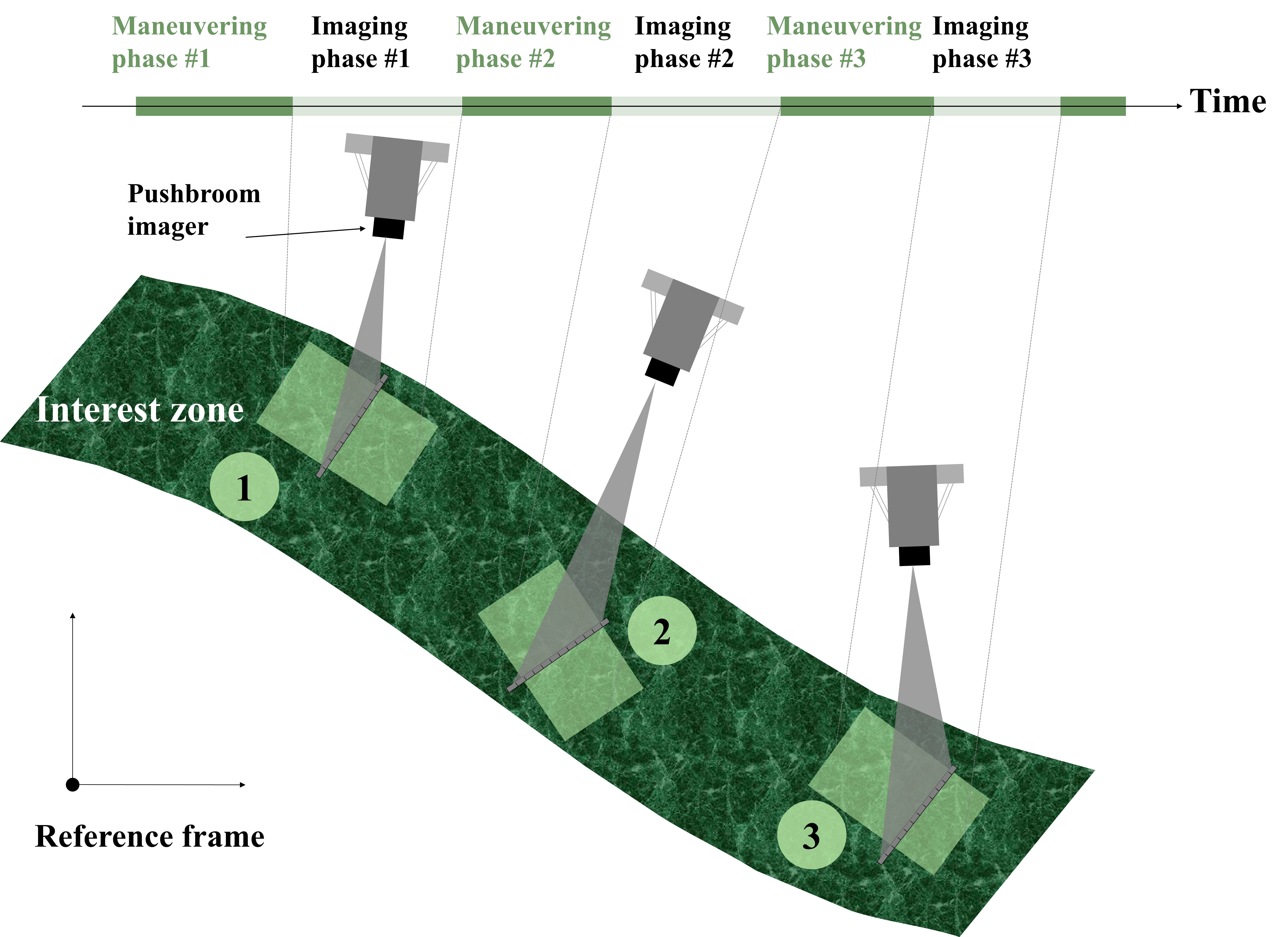
Agile maneuvering is crucial when imaging different target points, as the satellite's high orbital speed allows only a brief window to pass over specific areas. Efficient and precise operations are essential for capturing high-quality images of multiple targets within constrained timeframes.
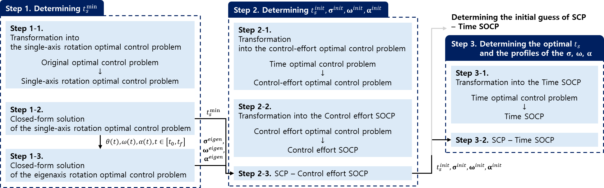
To address these challenges, the research team led by Prof. Donghun Lee developed an algorithm capable of generating stable and efficient attitude maneuver commands. This algorithm considers time constraints, hardware limitations, and observation requirements. For observation periods, a guidance profile algorithm was designed to enable target capture in any direction, rather than limiting operations to the satellite's direction of motion. Between observation periods, a numerical attitude guidance profile algorithm, as shown in Figure 2, was implemented to facilitate rapid maneuvers while adhering to the satellite's angular velocity and hardware constraints. Furthermore, an analytical solution was devised for specific scenarios, enabling the generation of attitude guidance profiles without relying on numerical calculations.
Most Popular

A New solution enabling soft growing robots to perform a variety of tasks in confined spaces
Read more
Development of a compact high-resolution spectrometer using a double-layer disordered metasurface
Read more
Towards a more reliable evaluation system than humans - BiGGen-Bench
Read more
AI-Designed carbon nanolattice: Feather-light, steel-strong
Read more
Dual‑Mode neuransistor for on‑chip liquid‑state computing
Read more