KAIST
BREAKTHROUGHS
Research Webzine of the KAIST College of Engineering since 2014
Spring 2025 Vol. 24Interpreting urban mobility big data with graph representation for air and surface transportation
Interpreting urban mobility big data with graph representation for air and surface transportation
The inundation of urban big data has engendered unprecedented opportunity for a future mobility revolution. Researchers at the TRUE Lab are tackling the challenge to effectively capture the spatial and temporal fluctuations of mobility data in graph representation, both for the air and surface transportation. In this article, a graph convolutional network for road traffic prediction and 3D airspace connectivity extraction are highlighted, demonstrating how urban big data can be interpreted with a graph neural network and computational topology.
Article | Special Issue
Transporting people and goods in urban environments with minimum cost and maximum safety is a decades-long desire for every commuter and traffic authority alike. With nearly ubiquitous personal mobile devices equipped with tracking capabilities, crowd movement big data has engendered unprecedented research opportunities to create and advance core mobility technologies for the current and future transportation.
One of the main challenges of urban mobility data lies in its spatio-temporal nature, which requires models to train and learn in the context of changing time and space. Adding to the already complex characteristics, urban mobility network is both spatially and temporally constrained with contiguity. Moreover, such constraints are different from comparable problems such as image recognition, as the spatial contiguity is sparse.
The Transportation Research and Urban Engineering (TRUE) Lab led by Prof. Yoonjin Yoon transforms the urban traffic and geospatial data into core mobility technology by representing and learning them in graphs, both for surface and air mobility.
In surface mobility, Yuyol Shin and Prof. Yoon formulated the classical short-term traffic prediction problem as spatio-temporal graph neural network called Multi-Weight Traffic Graph Convolutional (MW-TGC). MW-TGC captures the spatial and temporal constraint in graph representation to incorporate not only the time-dependent traffic state but also the static link characteristics such as speed limit, distance, and angle. The graph convolution operation learns the spatial features of urban transportation networks (Figure 1a). Road segment-wise dimension reduction is conducted to learn the lower dimension embedding of spatial features (Figure 1b). Lastly, a sequence-to-sequence framework is implemented to model the temporal variation in transportation network.
In the experiment, two sites of contrasting geospatial characteristics were selected in Seoul, South Korea. While urban-core is the local road network with homogeneous link characteristics, urban-mix is the mixture of local and arterial road links (Figure 1c). In a comparative study with five baseline models, MW-TGC reduced the RMSE of 1-hour prediction up to 30.3% in urban-core and 50.1% in urban-mix. MW-TGC network not only outperformed the comparative models in both sites but also reduced variance in the urban-mix network. MW-TGC network demonstrated the possibility of graph neural network applications for robust traffic forecasting. Such an outcome is especially valuable to learn a large urban road network with diverse spatial configurations. The research was published in IEEE Transactions on Intelligent Transportation Systems in October 2020.
In air mobility, the graph theoretic approach is especially effective to address the added complexity arising from vertical expansion. For the emerging technologies of small drones and air taxis to become an everyday mobility option, semantic mapping of the 3D urban airspace is imperative for safe and fast routing among the skyscrapers and urban dwellers. Dr. Jungwoo Cho and Prof. Yoon first proposed the concept of urban airspace layers of free (empty) vs usable (safe to fly) airspace using keep-in and keep-out geofences (Figure 2a). Employing computational topology methods of alpha-shape filtering and the Reeb graph, the proposed algorithms successfully identified the usable airspace in the highly constrained 3D spatial dataset of Gangnam in Seoul.
A hierarchical graph data structure was also proposed to further abstractize the 3D urban airspace in a larger scale (Figure 2b). Such transformation enables autonomous route extraction with conventional multi-agent pathfinding algorithms for high-density urban operations (Figure 2c). The research was published in Transportation Research Part C – Emerging Technologies in May 2018 and also presented in the ATM Seminar, which was the first ever representation of South Korea in the 26 years of the conference history.


Most Popular

When and why do graph neural networks become powerful?
Read more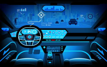
Smart Warnings: LLM-enabled personalized driver assistance
Read more
Extending the lifespan of next-generation lithium metal batteries with water
Read more
Professor Ki-Uk Kyung’s research team develops soft shape-morphing actuator capable of rapid 3D transformations
Read more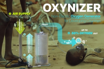
Oxynizer: Non-electric oxygen generator for developing countries
Read more