KAIST
BREAKTHROUGHS
Research Webzine of the KAIST College of Engineering since 2014
Spring 2025 Vol. 24Micro-weather Forecast for Urban Air Mobility
Forecasting local weather within the urban environment at high-resolution is critical for the success of Urban Air Mobility. Circumventing atmospheric gusts, rain, and fog will allow a safe and comfortable flight to a target destination. A recent predictive capability developed at KAIST is briefly summarized.
Article | Fall 2021
UAM (Urban Air Mobility), is the next-generation aerial transportation system that travels within the city limits with a small aircraft as a means of solving traffic congestion in a highly populated urban area. One major factor in the UAM take-off and landing decision is the local weather condition. A high-resolution real-time weather forecasting system is emerging as the key enabler for the UAM industry, which is about to become a reality in not-so-distant future. The Aerial Innovation Mobility Lab, led by Professor Sangbong Lee, employs a combination of computational fluid dynamics and machine learning to estimate weather conditions in the low-altitude urban areas at high resolution.
The weather forecasting system is initialized with RDAPS (Regional Data Assimilation and Prediction System) data, which serves as an input to a meso-scale weather forecast model, i.e., the WRF (Weather Research Forecast) model. The weather prediction data generated by WRF serves as a boundary condition for the micro-scale predictor to enable weather prediction at 10-meter (or less) resolution.

As shown in Fig. 1, complex flow developed downstream of the buildings tends to persist when buildings are densely packed and are parallel with the flow direction. The intensity of turbulence is highest in areas near free-flow regions downstream of buildings, which is non-intuitive and can be deceptive to pilots.
Using the WRF output data, micro-scale simulations were performed with increased resolution to resolve the detailed vortex structures. The surface roughness, which evolves depending on the geometric features of the local buildings in the vicinity, was included in the incoming turbulent atmospheric boundary layer to reflect realism in the simulation. To provide accurate three-dimensional forecasts, machine learning approach (Fig. 2) was employed to gain orders-of-magnitude improvements in computational speeds that were previously inaccessible.

Flow close to the Vertiport was the focus of the simulation, which revealed that wind speeds of 3, 4, 5 m/s were in accordance with the safety standards of mid-size helicopters. The average velocity variance was approximately 0.7 m/s, which was well below the 1.75 m/s safety limit for a conventional 8-ton helicopter. However, a typical UAM is less than 1/3 the helicopter’s weight such that an equivalent velocity variance of 0.7 m/s could impose critically unstable force during take-off and landing. Further studies will provide useful guidelines for safe UAM operation and enable further adaption of this novel transportation system in the near future.
Most Popular

When and why do graph neural networks become powerful?
Read more
Smart Warnings: LLM-enabled personalized driver assistance
Read more
Extending the lifespan of next-generation lithium metal batteries with water
Read more
Professor Ki-Uk Kyung’s research team develops soft shape-morphing actuator capable of rapid 3D transformations
Read more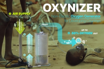
Oxynizer: Non-electric oxygen generator for developing countries
Read more