KAIST
BREAKTHROUGHS
Research Webzine of the KAIST College of Engineering since 2014
Spring 2025 Vol. 24Advanced geomorphological survey method using UAV-LiDAR for landslide analysis
Advanced geomorphological survey method using UAV-LiDAR for landslide analysis
A novel advanced geomorphological surveying technology enables the acquisition of high-resolution three-dimensional (3D) light detection and ranging (LiDAR) point clouds using an unmanned aerial vehicle (UAV), and this contributes to landslide recognition, mapping, monitoring, modeling, and mitigation.
Article | Fall 2021
In recent years, landslides occur more frequently in urban areas due to locally heavy rainfall, causing significant damage. Mitigation of catastrophic disasters requires accurate prediction of landslide characteristics, such as location and volume, and the extent of landslide-related damage through a flow analysis. Accordingly, high-resolution topographic information is crucial for the accurate prediction and characterization of potential landslides.
The research team, led by Professor Tae-Hyuk Kwon in the Department of Civil and Environmental Engineering, in collaboration with Professor Hyun Myung’s team in the School of Electrical Engineering, KAIST, has developed a novel advanced geomorphological surveying technology for landslide prediction, monitoring, and forensic analysis, and for the maintenance of barriers acquiring high-resolution three-dimensional (3D) LiDAR point clouds using an unmanned aerial vehicle (UAV, Figure 1). This technology enables the acquisition of terrain topographic data below canopy and vegetation, and thereby overcomes current limitations of ground-based platforms or UAV-photogrammetry. The developed system is composed of a UAV and a LiDAR sensor and is capable of efficient collection of high-resolution topographic data with a horizontal resolution less than 20 cm and a high accuracy with an error rate less than 0.15%.

This UAV-LiDAR system was successfully implemented for forensic analysis of the recent Gokseong landslide event, which occurred on August 7, 2020 (Figure 2). The initial and final volumes of the landslide were computed using the topographic information obtained from the 3D LiDAR sensor. Kwon and his team also explored the feasibility of using the developed system for sediment deposition monitoring for debris flow barrier maintenance. The team investigated a recently dredged closed-type barrier installed in Pocheon, South Korea using LiDAR and red-green-blue (RGB) point clouds (Figure 3). The developed surveying technology proved particularly promising in performing field geomorphological surveys in fields that are not easily accessible.
Due to these results, the team was awarded the Grand Prize for the Drone Image Challenge for Civil Infrastructures convened by the Korean Society of Civil Engineers (KSCE) in October 2020 (https://www.youtube.com/watch?v=ItlV3VgGHrI), and the research was published in Landslides (https://doi.org/10.1007/s10346-020-01616-y) in January 2021.


Most Popular

When and why do graph neural networks become powerful?
Read more
Smart Warnings: LLM-enabled personalized driver assistance
Read more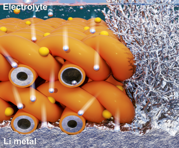
Extending the lifespan of next-generation lithium metal batteries with water
Read more
Professor Ki-Uk Kyung’s research team develops soft shape-morphing actuator capable of rapid 3D transformations
Read more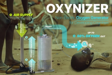
Oxynizer: Non-electric oxygen generator for developing countries
Read more